Applied Control
13705 Compark Blvd, Englewood, CO 80112
Territoire desservi – services et soutien
- All Counties Excluding:
- Montezuma
- La Plata
- All Counties Excluding:
- Lincoln
- Flathead
- Sanders
- Lake
- Mineral
- Ravalli
- Missoula - east of a north-south line drawn at the west side of the city of Missoula
- Banner
- Box Butte
- Chase
- Cheyenne
- Dawes
- Deuel
- Dundy
- Garden
- Keith
- Kimball
- Morrill
- Perkins
- Scotts Bluff
- Sheridan
- Sioux
- * parts of
- Butte
- Custer
- Fall River
- Harding
- Lawrence
- Meade
- Pennington
- Perkins
- Shannon
- * parts of
- All Counties Excluding:
- Lincoln
- Uinta
- Sublette
- Sweetwater - west of a projected line drawn due sough of the intersection of Fremont and Sublette counties at the Sweetwater border (the PP&L Jim Bridger Power Plant located three miles east of Point of Rocks, Wyoming is also included
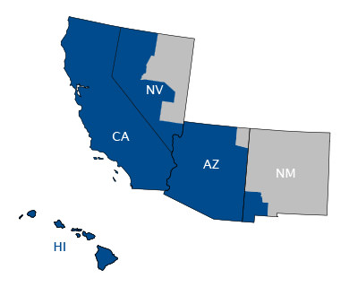
Caltrol
1385 Pama Lane Suite 111 Las Vegas, NV 89119
Territoire desservi – services et soutien
- Tous les comptés sauf Apache
- Tous les comptés
- Tous les comptés
- Tous les comptés à l'exception de :
- Elko
- Eureka
- Lander
- White Pine
- Lincoln
- Grant
- Luna
- Hidalgo
Control Associates
20 Commerce Drive Allendale, NJ 07401
Territoire desservi – services et soutien
- Tous les comptés è l'exception de :
- Altantic
- Burlington
- Camden
- Cape May
- Cumberland
- Glouchester
- Mercer
- Ocean
- Salem
- Bronx
- Kings
- Nassau
- New York
- Orange
- Putnam
- Queens
- Richmond
- Rockland
- Suffolk
- Westchester
- Tous les comptés à l'exception de :
- Windham
- New London
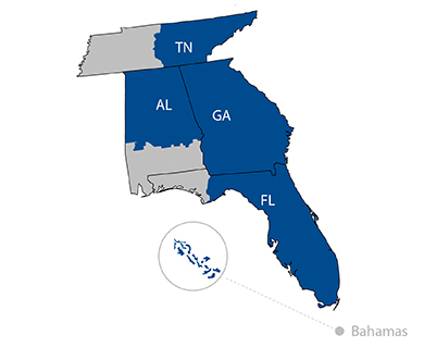
Control Southern
3850 Lakefield Drive Suwanee, GA 30024
Territoire desservi – services et soutien
- All Counties
- Anderson
- Bedford
- Bledsoe
- Blount
- Bradley
- Campbell
- Cannon
- Carter
- Claiborne
- Clay
- Cocke
- Coffee
- Cumberland
- Dekalb
- Fentress
- Franklin
- Grainger
- Greene
- Grundy
- Hamblen
- Hamilton
- Hancock
- Hawkins
- Jackson
- Jefferson
- Johnson
- Knox
- Loudon
- Macon
- Marion
- Mcminn
- Meigs
- Monroe
- Moore
- Morgan
- Overton
- Pickett
- Polk
- Putnam
- Rhea
- Roane
- Rutherford
- Scott
- Sequatchie
- Sevier
- Smith
- Sullivan
- Trousdale
- Unicoi
- Union
- Van Buren
- Warren
- Washington
- White
- Wilson
- All counties except
- Escambia
- Santa Rosa
- Okaloosa
- Walton
- Holmes
- Jackson
- Washington
- Calhoun
- Bay
- Gulf
- All Counties Excluding
- Choctaw
- Clarke
- Wilcox
- Butler
- Crenshaw
- Pike
- Barbour
- Washington
- Mobile
- Baldwin
- Monroe
- Conecuh
- Escambia
- Covington
- Geneva
- Houston
- Henry
- Dale
- Coffee
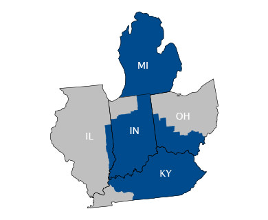
Cornerstone
7131 East Kemper Road Cincinnati, OH 45249
Territoire desservi – services et soutien
- All Counties Excluding
- Porter
- St Joseph
- La Porte
- Lake
- Adams
- Athens
- Brown
- Butler
- Clark
- Clermont
- Clinton
- Darke
- Fayette
- Gallia
- Greene
- Hamilton
- Highland
- Hocking
- Jackson
- Lawrence
- Mercer
- Miami
- Miegs
- Montgomery
- Pike
- Preble
- Ross
- Scioto
- Shelby
- Vinton
- Warren
- All counties Excluding
- Chippewa
- Mackinac
- Luce
- Schoolcraft
- Ontonagon
- Gogebic
- Houghton
- Baraga
- Dickinson
- Alger
- Marquette
- Iron
- Menominee
- Delta
- Vermillion
- Edgar
- Clark
- Crawford
- Lawrence
- Wabash
- All Counties Excluding
- Logan
- Ballard
- Carlisle
- Lyon
- McCracken
- Graves
- Crittenden
- Caldwell
- Christian
- Todd
- Trigg
- Marshall
- Hickman
- Fulton
- Calloway
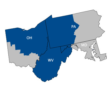
ECI
2 Park Drive P.O. Box 614 Lawrence, PA 15055
Territoire desservi – services et soutien
- Garrett
- Allegany
- Allegheny
- Armstrong
- Beaver
- Bedford
- Blair
- Butler
- Cambria
- Cameron
- Centre
- Clarion
- Clearfield
- Crawford
- Elk
- Erie
- Fayette
- Forest
- Franklin
- Fulton
- Greene
- Huntingdon
- Indiana
- Jefferson
- Lawrence
- McKean
- Mercer
- Potter
- Somerset
- Venango
- Warren
- Washington
- Westmoreland
- All Counties excluding:
- Adams
- Athens
- Brown
- Butler
- Clark
- Clermont
- Clinton
- Darke
- Fayette
- Gallia
- Greene
- Hamilton
- Highland
- Hocking
- Jackson
- Lawrence
- Mercer
- Miami
- Miegs
- Montgomery
- Pike
- Preble
- Ross
- Scioto
- Shelby
- Vinton
- Warren
- All Counties excluding:
- Berkeley *
- Jefferson *
- Morgan *
- * Select zip codes
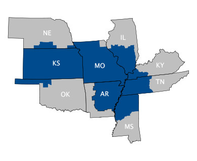
Experitec
11325 Strang Line Road Lenexa, KS 66215
Territoire desservi – services et soutien
- All counties
- All Counties excluding
- Scotland
- Clark
- Knox
- Lewis
- McCracken
- Carlisle
- Lyon
- Graves
- Ballard
- Logan
- Adams
- Furnas
- Franklin
- Gosper
- Harlan
- Kearney
- Pawnee
- Phelps
- Red Willow
- Richardson
- Webster
- Woods
- Woodward
- Beaver
- Texas
- Beaver
- Cimarron
- Bedford
- Benton
- Cannon
- Carroll
- Cheatham
- Chester
- Coffee
- Crockett
- Davidson
- Decatur
- Dickson
- Dyer
- Fayette
- Franklin
- Gibson
- Giles
- Hardeman
- Hardin
- Haywood
- Henderson
- Henry
- Hickman
- Houston
- Humphreys
- Lake
- Lauderdale
- Lawrence
- Lewis
- Lincoln
- Madison
- Marshall
- Maury
- McNairy
- Moore
- Montgomery
- Obion
- Perry
- Robertson
- Rutherford
- Shelby
- Stewart
- Sumner
- Tipton
- Trousdale
- Wayne
- Weakley
- Williamson
- Wilson
- Wayne
- Weakley
- Williamson
- Wilson
- McCracken
- Carlisle
- Lyon
- Graves
- Ballard
- Logan
- Bedford
- Benton
- Cannon
- Carroll
- Cheatham
- Chester
- Coffee
- Crockett
- Davidson
- Decatur
- Dickson
- Dyer
- Fayette
- Franklin
- Gibson
- Giles
- Hardeman
- Hardin
- Haywood
- Henderson
- Henry
- Hickman
- Houston
- Humphreys
- Lake
- Lauderdale
- Lawrence
- Lewis
- Lincoln
- Madison
- Marshall
- Maury
- McNairy
- Moore
- Montgomery
- Obion
- Perry
- Robertson
- Rutherford
- Shelby
- Stewart
- Sumner
- Tipton
- Trousdale
- Wayne
- Weakley
- Williamson
- Wilson
- Wayne
- Weakley
- Williamson
- Wilson
- All counties excluding:
- Benton
- Calhoun
- Carroll
- Columbia
- Crawford
- Franklin
- Hempstead
- Howard
- Johnson
- Lafayette
- Little River
- Logan
- Madison
- Miller
- Ouachita
- Polk
- Scott
- Sebastian
- Sevier
- Washington
- Alcorn
- Attala
- Benton
- Bolivar
- Calhoun
- Carroll
- Chickasaw
- Choctaw
- Clay
- Coahoma
- DeSoto
- Grenada
- Holmes
- Humphreys
- Issaquena
- Itawamba
- Lafayette
- Lee
- Leflore
- Marshall
- Monroe
- Montgomery
- Oktibbeha
- Panola
- Pontotoc
- Prentiss
- Quitman
- Sharkey
- Sunflower
- Tallahatchie
- Tate
- Tippah
- Tishomingo
- Tunica
- Union
- Washington
- Webster
- Yalobusha
- Yazoo
- All Counties excluding
- Novaspect territory
- Joe Daviess
- Carroll
- Whiteside
- Rock Island
- Henry
- Mercer
- Henderson
- Warren
- Hancock
- McDonough
- Adams
- Schuyler
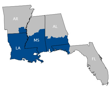
John H. Carter
17630 Perkins Road Baton Rouge, LA 70810
Territoire desservi – services et soutien
- Bradley
- Drew
- town of Huttig
- Warren
- Hinds
- Madison
- Leake
- Winston
- Noxubee
- Neshoba
- Kember
- Rankin
- Scott
- Newton
- Lauderdale
- Claiborne
- Copiah
- Simpson
- Smith
- Jasper
- Clarke
- Jefferson
- Adams
- Franklin
- Wilkinson
- Amite
- Lincoln
- Pike
- Walthall
- Lawrence
- Jefferson Davis
- Marion
- Covington
- Lamar
- Pearl River
- Hancock
- Harrison
- Stone
- Forrest
- Jones
- Wayne
- Perry
- Greene
- George
- Jackson
- Choctaw
- Clarke
- Wilcox
- Butler
- Crenshaw
- Pike
- Barbour
- Washington
- Mobile
- Baldwin
- Monroe
- Conecuh
- Escambia
- Covington
- Geneva
- Houston
- Henry
- Dale
- Coffee
- Escambia
- Santa Rosa
- Okaloosa
- Walton
- Holmes
- Jackson
- Washington
- Calhoun
- Bay
- Gulf
- All Counties / Parishes
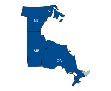
Lakeside
2475 Hogan Drive Mississauga, ON
Territoire desservi – services et soutien
- Ontario *
- Manitoba
- Kivalliq, Nunavut
- * excluding Ottawa Valley
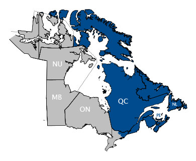
Laurentide
18000, route Transcanadienne Kirkland, Québec
Territoire desservi – services et soutien
- Québec
- Nouveau-Brunswick
- Nouvelle-Écosse
- Île-du-Prince-Édouard
- Terre-Neuve-et-Labrador
- Vallée de l'Outaouais
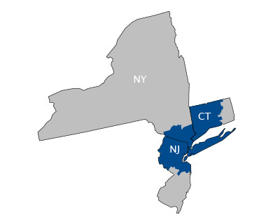
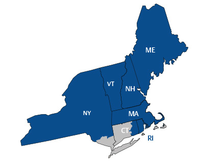
NECI
325 Foxborough Blvd., Foxborough, MA 02035
Territoire desservi – services et soutien
- Barnstable
- Bristol
- Dukes
- Essex
- Middlesex
- Mantucket
- Norfolk
- Plymouth
- Suffolk
- Worcester
- All counties excluding
- Bennington
- Windham
- Windham
- New London
- Aroostook
- Cumberland
- Franklin
- Hancock
- Kennebec
- Knox
- Lincoln
- Oxford
- Penobscot
- Piscataquis
- Sagadahoc
- Somerset
- Waldo
- Washington
- York
- All Counties
- All counties
- All counties
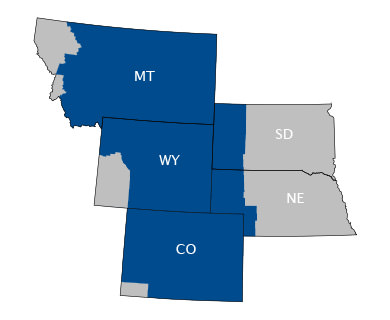
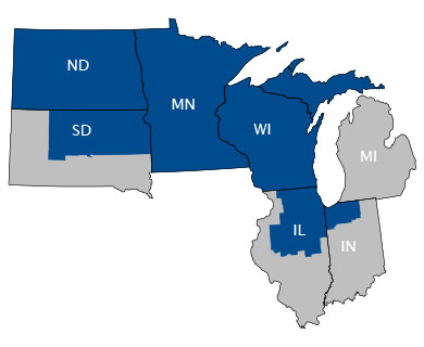
Novaspect
1124 Tower Road Schaumburg, IL 60173
Territoire desservi – services et soutien
- All counties
- All counties
- All counties
- Porter
- St Joseph
- La Porte
- Lake
- Chippewa
- Mackinac
- Luce
- Schoolcraft
- Ontonagon
- Gogebic
- Houghton
- Baraga
- Dickinson
- Alger
- Marquette
- Iron
- Menominee
- Delta
- All Counties Excluding:
- Butte
- Custer
- Fall River
- Harding
- Lawrence
- Meade
- Pennington
- Perkins
- Shannon
- Moody
- Lake
- Miner
- Sanborn
- Jerauld
- Buffalo
- Lyman
- Jones
- Jackson
- Washabaugh
- Bennett
- Mellette
- Todd
- Tripp
- Brule
- Gregory
- Charles Mix
- Aurora
- Douglas
- Davison
- Hanson
- Hutchinson
- Bon Homme
- McCook
- Turner
- Yankton
- Minnehaha
- Lincoln
- Clay
- Union
- All counties
- All counties excluding
- Joe Daviess
- Carroll
- Whiteside
- Rock Island
- Henry
- Mercer
- Henderson
- Warren
- Hancock
- McDonough
- Adams
- Schuyler
- Coles
- Moultrie
- Macoupin
- Jersey
- Bond
- Jasper
- Macon
- Cass
- Scott
- Calhoun
- Morgan
- Greene
- Madison
- St. Clair
- Monroe
- Randolph
- Christian
- Shelby
- Montgomery
- Clinton
- Washington
- Perry
- Jackson
- Union
- Johnson
- Williamson
- Franklin
- Jefferson
- Marion
- Fayette
- Clay
- Saline
- Wayne
- Hardin
- Pike
- Brown
- Effingham
- Richland
- Cumberland
- Edwards
- Sangamon
- Hamilton
- White
- Gallatin
- Massac
- Alexander
- Pope
- Anetlope
- Arthur
- Blaine
- Boone
- Boyd
- Brown
- Buffalo
- Burt
- Butler
- Cass
- Cedar
- Cherry
- Clay
- Colfax
- Cuming
- Custer
- Dakota
- Dawson
- Dixon
- Dodge
- Douglas
- Fillmore
- Frontier
- Gage
- Garfield
- Grant
- Greeley
- Hall
- Hamilton
- Hayes
- Hitchcock
- Holt
- Hooker
- Howard
- Jefferson
- Johnson
- Keya Paha
- Knox
- Lancaster
- Lincoln
- Logan
- Loup
- Madison
- McPherson
- Merrick
- Nance
- Nemaha
- Nuckolls
- Otoe
- Pierce
- Platte
- Polk
- Rock
- Saline
- Sarpy
- Saunders
- Seward
- Sherman
- Stanton
- Thayer
- Thomas
- Thurston
- Valley
- Washington
- Wayne
- Wheeler
- York
- Scotland
- Clark
- Knox
- Lewis
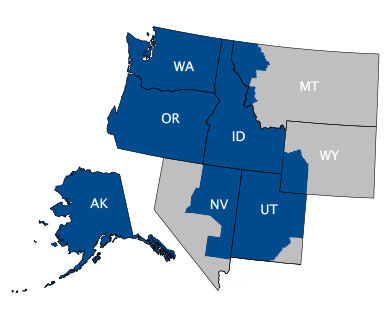
PCE Pacific
22011 26th Avenue SE Bothell, WA 98021
Territoire desservi – services et soutien
- All counties
- All counties
- All counties
- All counties
- All counties except San Juan
- Lincoln
- Flathead
- Sanders
- Lake
- Mineral
- Ravalli
- Missoula - west of a north-south line drawn at the west side of the city of Missoula
- Lincoln
- Uinta
- Sublette
- Sweetwater - west of a projected line drawn due sough of the intersection of Fremont and Sublette counties at the Sweetwater border (the PP&L Jim Bridger Power Plant located three miles east of Point of Rocks, Wyoming is also included
- Elko
- Eureka
- Lander
- White Pine
- Lincoln
Proconex
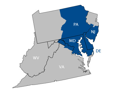
103 Enterprise Dr, Royersford, PA 19468
Territoire desservi – services et soutien
- Adams
- Berks
- Bradford
- Bucks
- Carbon
- Chester
- Columbia
- Cumberland
- Dauphin
- Delaware
- Franklin
- Juniata
- Lackawanna
- Lancaster
- Lebanon
- Lehigh
- Luzerne
- Lycoming
- Mifflin
- Monroe
- Montogomery
- Montour
- Northampton
- Northumbrland
- Perry
- Philadelphia
- Pike
- Schuylkill
- Snyder
- Sullivan
- Susquehanna
- Tioga
- Union
- Wayne
- Wyoming
- York
- Kent
- New Castle
- Sussex
- All counties excluding:
- Garrett
- Allegany
- Altantic
- Burlington
- Camden
- Cape May
- Cumberland
- Glouchester
- Mercer
- Ocean
- Salem
- Arlington
- Fairfax
- Loudoun
- Berkeley *
- Jefferson *
- Morgan *
- * Select zip codes
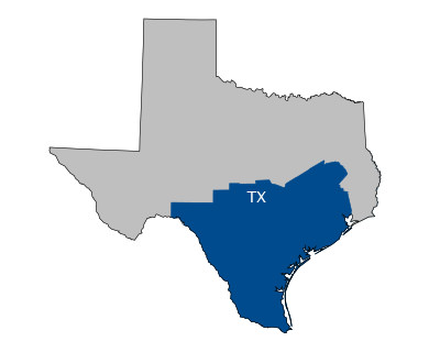
Puffer-Sweiven
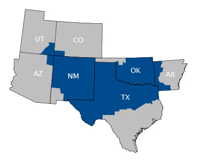
4230 GREENBRIAR, STAFFORD, TEXAS 77477
Territoire desservi – services et soutien
- Atascosa
- Bee
- Bexar
- Brazos
- Brazoria
- Burleson
- Calhoun
- Chambers (west of the Trinity River)
- DeWitt
- Dimmit
- Fayette
- Fort Bend
- Galveston
- Goliad
- Gonzales
- Grimes
- Harris
- Karnes
- La Salle
- Lavaca
- Lee
- Liberty (West of Trinity River)
- Live Oak
- Madison
- Matagorda
- McMullen
- Montgomery
- Nueces
- Robertson
- San Patricio
- Travis
- Victoria
- Waller
- Washington
- Webb
- Wilson
RE Mason
1726 North Graham Street Charlotte, NC 28206
Territoire desservi – services et soutien
- All Counties
- All Counties
- All Counties

Scallon
4850 Romeda Road Beaumont, TX 77705
Territoire desservi – services et soutien
- Angelina
- Chambers *
- Hardin
- Jasper
- Jefferson
- Liberty
- Newton
- Nacogdoches
- Orange
- Polk
- Sabine
- San Augustine
- Shelby
- Tyler
- (All in SE Texas)
- *East of Trinity River

Spartan
305 - 27 STREET SE, CALGARY, ALBERTA, CANADA T2A 7V2
Territoire desservi – services et soutien
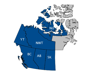
- Alberta
- British Columbia
- Saskatchewan
- Yukon
- Nunavut *
- *excluding Kivalliq
Vinson
2747 Highpoint Oaks Dr. Lewisville, TX 75067
Territoire desservi – services et soutien
- All counties excluding:
- Angelina
- Chambers
- Hardin
- Jasper
- Jefferson
- Liberty
- Newton
- Nacogdoches
- Orange
- Polk
- Sabine
- San Augustine
- Shelby
- Tyler
- Atascosa
- Bee
- Bexar
- Brazos
- Brazoria
- Burleson
- Calhoun
- DeWitt
- Dimmit
- Fayette
- Fort Bend
- Galveston
- Goliad
- Gonzales
- Grimes
- Harris
- Karnes
- La Salle
- Lavaca
- Lee
- Live Oak
- Madison
- Matagorda
- McMullen
- Montgomery
- Nueces
- Robertson
- San Patricio
- Travis
- Victoria
- Waller
- Washington
- Webb
- Wilson
- Adair
- Alfalfa
- Atoka
- Beckham
- Blaine
- Bryan
- Caddo
- Canadian
- Carter
- Cherokee
- Choctaw
- Cleveland
- Coal
- Comanche
- Cotton
- Craig
- Creek
- Custer
- Delaware
- Dewey
- Ellis
- Garfield
- Garvin
- Grady
- Grant
- Greer
- Harmon
- Haskell
- Hughes
- Jackson
- Jefferson
- Johnston
- Kay
- Kingfisher
- Kiowa
- Latimer
- Le Flore
- Lincoln
- Logan
- Love
- Major
- Marshall
- Mayes
- McClain
- McCurtain
- Mcintosh
- Murray
- Muskogee
- Noble
- Nowata
- Okfuskee
- Oklahoma
- Okmulgee
- Osage
- Ottawa
- Pawnee
- Payne
- Pitsburg
- Pontotoc
- Pottawatomie
- Pushmataha
- Roger Mills
- Rohers
- Seminole
- Sequoyah
- Stephens
- Tillman
- Tulsa
- Wagoner
- Washington
- Washita
- Bernalillo
- Catron
- Chaves
- Cibola
- Colfax
- Curry
- Curry
- DeBaca
- Dona Ana
- Eddy
- Guadalupe
- Harding
- Lea
- Lincoln
- Los Alamos
- McKinley
- Mora
- Otero
- Quay
- Rio Arriba
- Roosevelt
- San Juan
- Sandoval
- Sierra
- Soccoro
- Taos
- Torrance
- Union
- Valencia
- Benton
- Calhoun
- Carroll
- Columbia
- Crawford
- Franklin
- Hempstead
- Howard
- Johnson
- Lafayette
- Little River
- Logan
- Madison
- Miller
- Ouachita
- Polk
- Scott
- Sebastian
- Sevier
- Washington
- Montezuma
- La Plata
- San Juan
- Apache